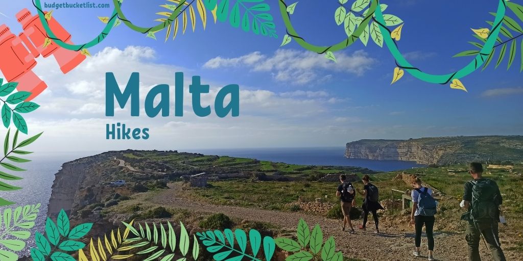
Malta Hikes
For budget tips & compact place-specific travel info... Download my FREE Budget Fact Sheets. You're welcome.
| Download Steph's MALTA Quick Budget Fact Sheet |
There are very few things in life I consider more satisfying than hiking. Maybe sex? Hm, if it’s with panoramic viewpoints to accompany the highlights... So, quite logically, when I made my 7-months-move to Malta to ride out covid-hell, the first thing I did is tie on my hiking boots and start randomly walking into different directions. No better way to see, or better said: feel the island… the pace allowing for a slow and thorough absorption of the very essence of each village and every cliff.
I for sure didn’t fool around. After 2-3 months I struggled to find a trail not walked twice already on my scarce days off, and once the unbearable Maltese summer heat seeped in, I had to conclude I “finished” the mini-country of Malta, hiking-wise – incl. the full north-south stretch and the entire 179km coastal trail around the main island (Gozo done separately), completed with a tent on my back.
By now, I think I’m qualified to throw in some recommendations:
Malta Full Coastal Loop (179 km)
[Stretches can also be walked individually]
Too busy to read now? No problem, save it for later!
Save on Get Pocket | Save in Browser Bookmarks| Save on Instapaper
Save on Get Pocket | Save in Browser Bookmarks| Save on Instapaper
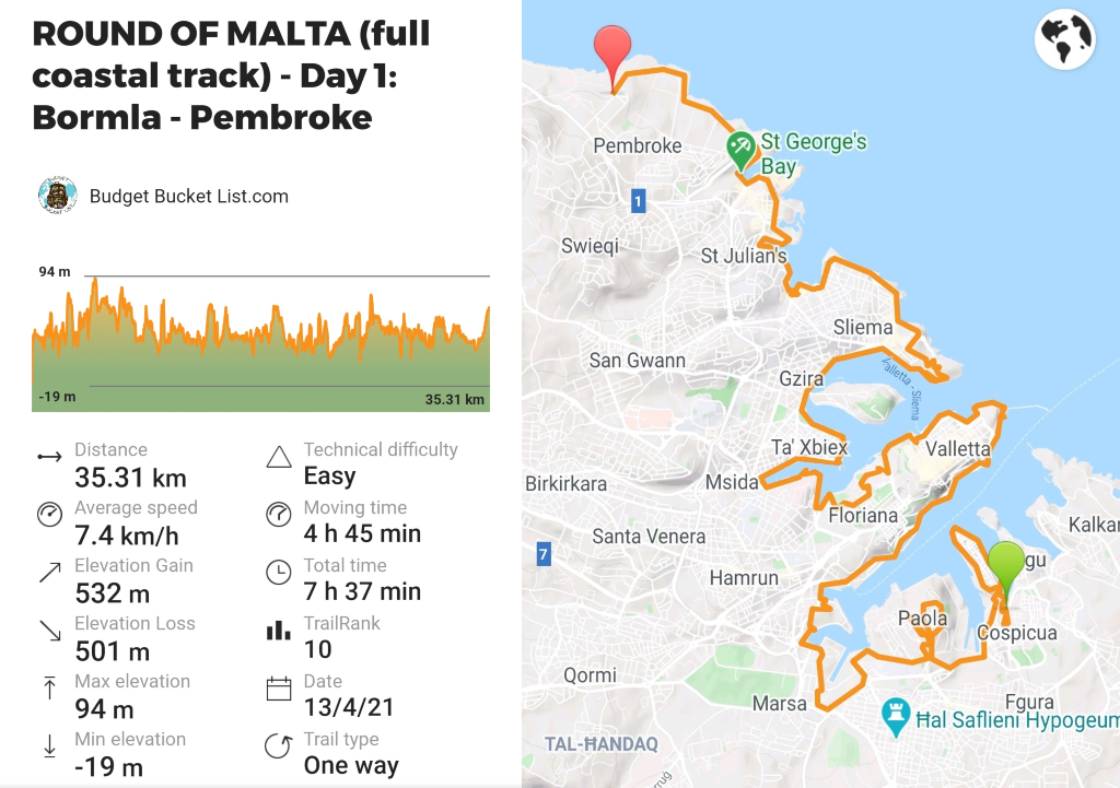
Day 1: Cospicua (Bormla) – Pembroke (35.3 km) *
The idea was to walk from my house in Cospicua until Bugibba, where I could crash at a friend’s place. Yeah… I’m full of good ideas... It might not look as much on the map, but with the swirling coastline marked by various peninsula’s we’re looking at about 50 km. Bit much! I made a brave attempt of 35 km, passing some of the best cities of Malta (The Three Cities & Valletta), but most definitely also the worst part… now I’m not only referring to the - in my opinion - despicable stretches of Sliema and St. Julians, but I’m also including the strolls passed industrial zones marked with trash and condom-trails towards dodgy carton-bang-hangs in filthy corners. A necessary evil to be defeated for the higher goal: being able to say you walked the entire coastline of Malta.
Terrain: Mainly streets and sidewalks.
Level of difficulty: Easy.
Towns (water / food): Along the entire way.
Buses to beginning / end point: Bormla: Bus 1, 2, 3, 4, 124, 213 – Pembroke: Bus 13, TD13, 14, 16.
Remarks: Not recommended as a day hike if you’re not doing the full Round of Malta.
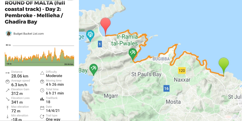
Day 2: Pembroke – Mellieha (28 km) ***
I took the bus back to the exact point where I decided enough was enough the day before. No cheating! I was quite scared of this part as well, as I am familiar with the lingering highway right along the coast. Great for vehicle-owners… not so much for those who enjoy a quiet and peaceful walk along the shore. However, I felt like once I passed Bugibba, Malta “began”… its true essence shining through in its magnificent glory. Instead of man-made promenades and highway-sidewalks, actual trails start to appear. The sounds of traffic delightfully fade away, motorways making space for far-away cliffs. To my great pleasure this stretch includes the natural area around Mistra and Imġiebaħ Bay, a lesser-known pebble stone beach tucked away amidst sumptuous hills and sapphire waters. Once the finish line of the day slowly came in sight, I tossed my sweaty attire behind me and thoughtlessly fell back into the Mediterranean Sea. Stark naked, as May is that marvellous season when the colors still pop, the sun doesn’t attempt to kill you, and tourists didn’t find their way over yet… During this time of the year, these magical places are there for you to enjoy entirely solo! Hiking how it’s meant to be.
Terrain: Combination of promenades and actual trails – quite mellow!
Level of difficulty: Easy.
Towns (water / food): Bugibba, St. Paul’s Bay, Mellieha.
Buses to beginning / end point: Pembroke: Bus 13, TD13, 14, 16 – Mellieha: Bus 41, 42, 44, 49, 250.
Remarks: If you do this as a day hike, start off at Bugibba to avoid the highway and continue a bit further than just Mellieha.
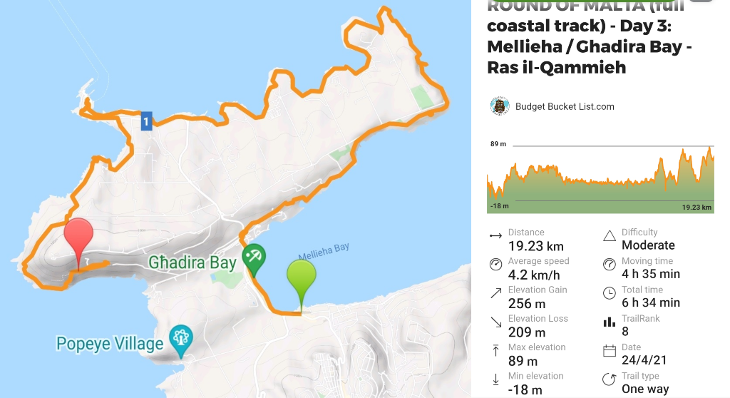
Day 3: Mellieha – Għadira Bay / Ras il-Qammieħ (19.2 km) ****
This stretch, as also the upcoming one, I was joined by a friend. As always, that means you have to adjust the pace to what is comfortable to the other, which is a small price to pay for pleasant company… even if that means you will walk the Malta Full Coastal Loop in 7 days instead of the possible 6. I’m glad he joined this part specifically, as it’s an amazing patch along breath-taking cliffs, low forests, and forlorn fishing villages many non-Maltese haven’t even heard of, along the route slyly offering some sneak-peaks onto the other Maltese islands Gozo and Comino. Special mention for the intriguing Coral Lagoon sinkhole! Even though we made the unforgivable hiking mistake of not bringing enough water with us, local farmers provided us with enough refills to allow us to wild-camp at a downright epic location overlooking the orange northern ridges giving that unmistakable character to Malta.
Terrain: Trails and off-trail sections including ankle-breaking pointy rocks to balance on.
Level of difficulty: Moderate.
Towns (water / food): Melieha, L-Armier – in high season food trucks can be found along the beach areas, in off-season there is nothing.
Buses to beginning / end point: Mellieha: Bus 41, 42, 44, 49, 250 - Għadira Bay: Bus 41, 42, 49, 250, X1.
Remarks: Prepare for the limited food and water availability. Bring hiking poles for the uneven terrain.
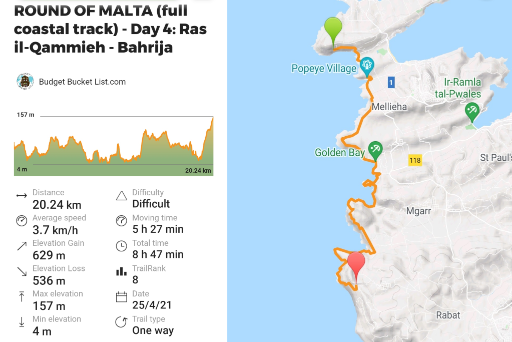
Day 4: Għadira Bay / Ras il-Qammieħ – Baħrija (20.2 km) *****
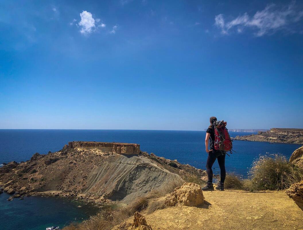
If yesterday could already be defined as memorable, imagine waking up overlooking that fantastic panorama, while preparing your breakfast and coffee at your camping gas stove. That’s living! To all people who hate camping: your loss. A heavenly start to a brutal yet stunning day, passing rough foreshore, the properly tacky Popeye Village and Malta’s most well-known sand beaches: Golden Bay, Tuffieħa Bay and Gnejna Bay. I noticed that most people who walked the coastal track and recorded their whereabouts didn’t actually follow the coastline here, and I now understand why: it’s mainly off-trail, passing uneven rocky terrain, and often involving actual rope-climbing instead of hiking (with massive backpacks full of camping gear, mind you). The most demanding day so far, which we completed with a staggering slow 3.7 km/h, leaving us completely destroyed at sunset. That said, it was also the most beautiful day of the entire Round of Malta, so I strongly recommend accepting this challenge the way I walked it.
Terrain: Trails, off-trail and rope-climbing.
Level of difficulty: Difficult.
Towns (water / food): Just the restaurant / hotel at Golden Bay. More foodtrucks in high season available, but not too many.
Buses to beginning / end point: Għadira Bay: Bus 41, 42, 49, 250, X1 – Baħrija: Bus 109 (often cancelled in the weekend).
Remarks: This and the upcoming stretch involve some “trespassing”, which isn’t actually trespassing as locals just put random gates around public coastline nowadays, illegally, and the Maltese government is too inefficient to catch up with that. It’s a big news item and ongoing discussion point, but remember: they are wrong, you are in your full right… climb that gate! F*ck ‘em!
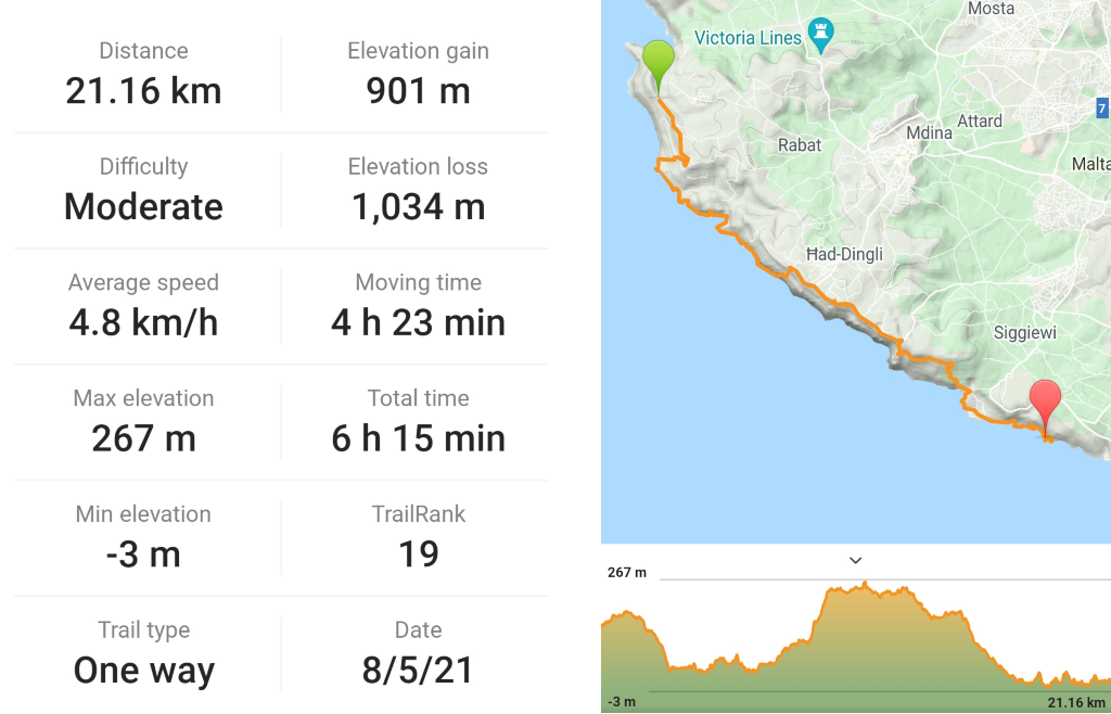
Day 5: Baħrija – Hagar Qim / Blue Grotto (21.2 km) *****
The combination of a non-functioning bus system in Malta and my non-functioning brain in the morning hours made me arrive extremely late at Baħrija: the spot where I stopped my Round of Malta my last 2 days off, and where I as such continued today (I still had to walk 2 km to get to it). It was my lucky day, as not only was the hot weather cooled down by a pleasant sea breeze, the stretch I was going to hike today is amazing: the Mthaleb and Dingli Cliffs! I hiked all of it before already, but never with a 15kg pack full of camping gear and water. This significantly slowed me down and took a toll on my feet, but hey, worth it! This east side of Malta is undoubtedly as good as it gets, especially when it comes to hiking.
When night fell, I was a bit in a pickle, as I was exactly in a coastal erosion area with rocks 10 times the size of my head just randomly crashing from the cliffs down on the trails. But the alternative was continuing into civilization, which is by all means worse, so I decided to stop walking earlier than planned. After finding a few "perfect spots" that weren't so perfect after all as that's exactly right where all previous rocks had rolled into the direction of, I had to settle with a flat but rocky and windy patch on the cliffs, just under the ancient Hagar Qim megalithic temples (one of the oldest structures WORLDWIDE, definitely worth a visit when you have time). In Malta I had never seen a shooting star before, but this night was the premiere… it seemed fitting!
Terrain: Mostly trails, some sidewalks and also off-trail patches.
Level of difficulty: Moderate.
Towns (water / food): None, but at the Blue Grotto and Dingli Cliffs there are a few restaurants (off-season closed).
Buses to beginning / end point: Baħrija: Bus 109 (often cancelled in the weekend) – Hagar Qim: Bus 74, 201 (with steep off-trail drop down to get to the coastline).
Remarks: Prepare for limited food and water sources.
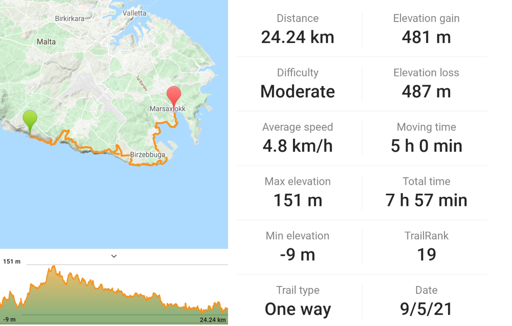
Day 6: Hagar Qim / Blue Grotto – Marsaxlokk (24.2 km) **
However quiet and desolate my camping spot was in the evening... to my great surprise it was swarming with hikers, trail runners and beach-goers around my tent when I woke up (at 7:30AM for crying out loud). Really, why? Anyway, pretty awesome I could just wake up with a refreshing dive in the Mediterranean Sea and be on my merry way.
Today contained a sweet span over the cliffs just past the Blue Grotto, a rightful tourist magnet. It unfortunately also included some downright boring patches along factories and the industrial harbour, and busy monotonous roads I was happy to leave behind eventually… but at least I spiced up that part by stepping on a western whip snake. Poor thing. Turned out I was quite lucky, as although it isn’t venomous (only the cat snake is in Malta, although defenitely not deadly), it can strike and bite viciously when cornered or threatened (but hey, I can’t blame him, I’d do the same).
I stopped in the pleasant fisherman’s village of Marsaxlokk, where I often come to visit the sunday market. A good point to rest the feet and down a well-deserved wine: Only 1 day left to complete the circle!
Terrain: Combination of trails and sidewalks.
Level of difficulty: Moderate.
Towns (water / food): Birzebuggia – Marsaxlokk.
Buses to beginning / end point: Hagar Qim: Bus 74, 201 (with steep off-trail drop down to get to the coastline) – Marsaxlokk: Bus 81, 82, 85.
Remarks: This is not recommended as a day hike per se. Not too scenic, except of the stretch before and after the Blue Grotto.
Day 7: Marsaxlokk – Cospicua (Bormla) (30.4 km) ***
The last day of the Round of Malta! Not quite the unknown terrain for me, as I walked all of it before... but I was excited nevertheless because of the symbolic meaning. Kicking off quite pleasantly in my beloved Marsaxlokk, I followed a gorgeous trail leading past the lighthouse, St. Peters Pool (although I think the neighbouring bays are much cleaner and more peaceful than this Instagram-hit) and crisp white cliffs, smooth as whipped cream, embellished by intense greenery in spring-time almost resembling Indonesian rice paddies. My little expedition was pleasantly interrupted with a little wine ‘n dine in Marsaskala, provided by my dear Spanish friend Jonathan, making me tipsy enough to hardly realize I wasn’t even half-way. From Marsaskala towards the Three Cities one can find mainly rugged drop-offs, shaped by the aggressive slams of violent waves beating up the shoreline. Keep an eye out for Fort Rinella, film location for among others The Gladiator, Troy, and Game of Thrones.
I finished exactly where I started: my lil' Cospicua / Bormla in the Three Cities. Still my favourite part of Malta, where I moved to for a very clear reason. At exactly 178.68 km (plus the ca. 15km extra walking to and from the exact starting/ending points), About an average of 26-27km a day. Not bad for some weekend breaks amidst my temporary episode of covid-forced civilized working life!
Terrain: Combination of trails and sidewalks.
Level of difficulty: Easy.
Towns (water / food): Marsaxlokk, Marsaskala, Xghajra, Kalkara, Birgu, Bormla / Cospicua.
Buses to beginning / end point: Marsaxlokk: Bus 80, 81, 82,85. Bormla: Bus 1, 2, 3, 4, 124, 213
Remarks: -

Recommended Day Hikes
[Listed from favorite to least favorite]
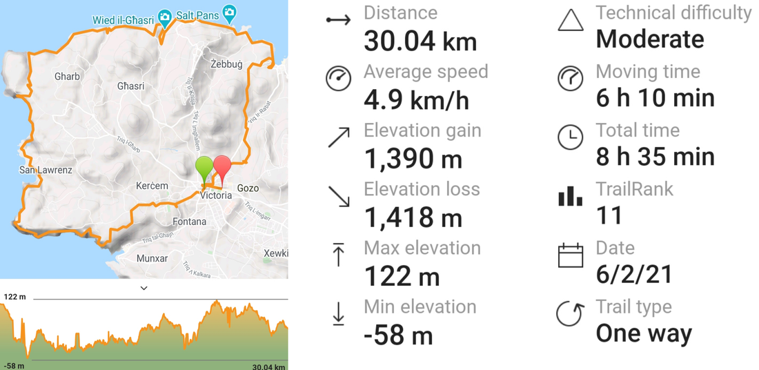
Gozo: Northern Loop (30 km) *****
The island of Malta is lovely… Hiking-wise, Gozo is your best bet though, the three islands considered. Especially in spring, when the island sparkles with lush greenery, right before the yellow, dusty drought of summer sets in. I have looped the entire coast of Gozo on several occasions, but never in one go. In this northern loop, starting and ending in Victoria (the island’s capital and location of most accommodation options), and passing Xlendi, San Lawrenz and Zebugg, you score on almost all highlights of the Malta-outdoors-bingo: Nature off-road trails, dramatic cliffs, salt pans, the typical “wieds” (sea inlets) and even the now-collapsed Azure Window, which was once one of the icons of Malta and a famous film location of Game of Thrones. Beaches are a rare commodity on this stretch, but the crystal blue sea remains inviting and the scenery is simply outstanding. One of my favorites!
Terrain: Combination of trails and dirt roads.
Level of difficulty: Moderate.
Towns (water / food): Victoria, Marsalforn, Xlendi, Zebugg. In summer there are some food trucks along the more remote coastal areas.
Buses to beginning / end point: Victoria: Bus 301, 303, 323 (from Mgarr Harbour).
Remarks: If you’d like to do a full coastal loop around Gozo, you can skip the part to and from Victoria. Bring a tent and it can be done in 2 days, 3 max.
[Listed from favorite to least favorite]
Gozo: Northern Loop (30 km) *****
The island of Malta is lovely… Hiking-wise, Gozo is your best bet though, the three islands considered. Especially in spring, when the island sparkles with lush greenery, right before the yellow, dusty drought of summer sets in. I have looped the entire coast of Gozo on several occasions, but never in one go. In this northern loop, starting and ending in Victoria (the island’s capital and location of most accommodation options), and passing Xlendi, San Lawrenz and Zebugg, you score on almost all highlights of the Malta-outdoors-bingo: Nature off-road trails, dramatic cliffs, salt pans, the typical “wieds” (sea inlets) and even the now-collapsed Azure Window, which was once one of the icons of Malta and a famous film location of Game of Thrones. Beaches are a rare commodity on this stretch, but the crystal blue sea remains inviting and the scenery is simply outstanding. One of my favorites!
Terrain: Combination of trails and dirt roads.
Level of difficulty: Moderate.
Towns (water / food): Victoria, Marsalforn, Xlendi, Zebugg. In summer there are some food trucks along the more remote coastal areas.
Buses to beginning / end point: Victoria: Bus 301, 303, 323 (from Mgarr Harbour).
Remarks: If you’d like to do a full coastal loop around Gozo, you can skip the part to and from Victoria. Bring a tent and it can be done in 2 days, 3 max.
Gozo: Southern Loop (45 km) *****
What can be done with the north, obviously also works for the south. As I was with a larger group of people, we knocked this one out in two days, starting from the Gozo ferry terminal in Mgarr and hiking up to Victoria along the south-west side, to bend down back to the terminal again the next day. Where in the northern part the elevation is generally slightly higher, but stable, this hike contains quite some ups and downs adding an extra tad of challenge to the equation. I hiked this stretch both in spring and summer, and these two experiences are a world apart: From overwhelmingly blooming landscapes to an entirely colourless desert scorching in a 45 degrees heat making every step a torture. Summer might be high season, but in my opinion it’s the worst one of all in Malta.
Terrain: Trails, lots of ups and downs.
Level of difficulty: Moderate.
Towns (water / food): Mgarr, Xlendi, Victoria, Marsalforn, Nadur, Qala.
Buses to beginning / end point: Mgarr is the ferry terminal connecting to the Malta island. From Victoria you can take bus 301, 303, 323.
Remarks: -
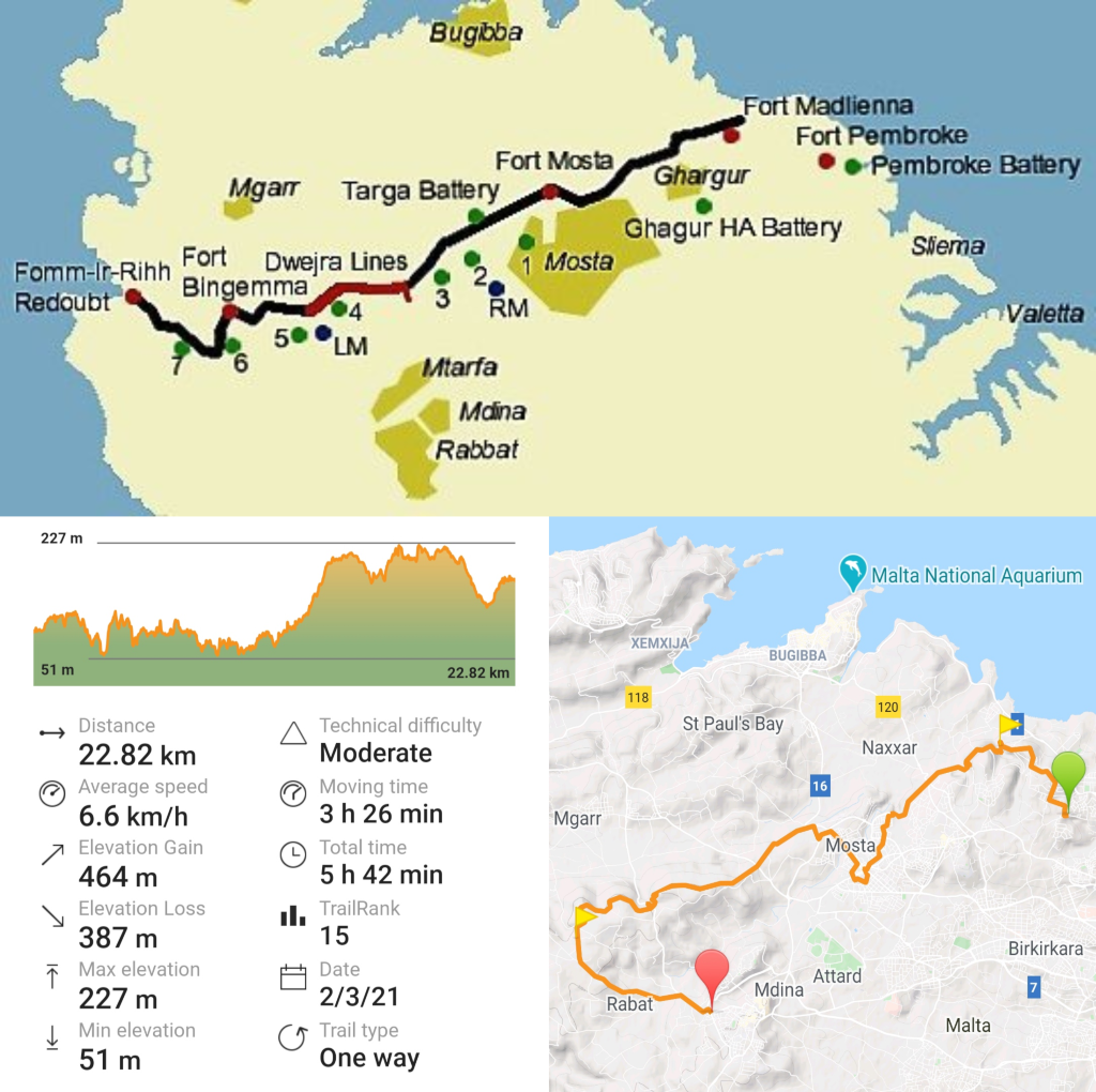
Malta: Victoria Lines (Between 12-22.8km) *****
Hands down my favorite day hike on the Malta-island. A rather easy one too, if that’s something that concerns you. The Victoria Lines was originally designed as a North West Front: a line of fortifications that spans 12 kilometres along the width of the island, dividing the north and south. Nowadays, locals nickname it “the Great Wall of Malta”, even though in length it hardly compares to the Chinese original. It’s quite impressive to literally hike over the ancient defence lines cutting the island in two, stretching from coast to coast, breathing in both history and the best of local countryside with every step. Personally, I slightly mixed and matched the hike, starting at the original start/end of the trail close to Pembroke (hiking from the nearest bus station) and making a detour into the authentic town of Mosta to visit the Rotunda, built to resemble the Pantheon of Rome and famous for its WWII “miracle” (a Nazi bomb penetrated the dome during mass, but failed to explode). As darkness set in before I reached the opposing coast, and public transport is non-existent here, I bent off to the left to hike towards Rabat where buses pass frequently… but adding a significant distance to the original hike. The missed patches I hiked on several occasions at different times. However, the original hike is as displayed below:
Terrain: Combination of walking over the ancient walls and some slightly overgrown trails.
Level of difficulty: Moderate.
Towns (water / food): Pembroke, Swieqi, Gharghur, Mosta.
Buses to beginning / end point: Swieqi: Bus 13, 14, 212. Baħrija: Bus 109 (often cancelled in the weekend).
Remarks: Beginning and end slightly hard to find, but the original trail goes from coast to coast. Check the marking in my recorded trail to find the entry from Swieqi / Pembroke, as it’s not obvious.
Malta: Golden Bay – Mdina (20 km) *****
If you ask me to mention to most scenic stretch of the Malta-island (excluding Gozo / Comino), I’d immediately refer to the western coast. Particularly the stretch from Paradise Bay along the beaches of Golden / Għajn Tuffieħa Bay, the Mthaleb Cliffs, and the Dingli Cliffs. That’s not just my opinion, every Maltese I ever spoke to immediately smiled in agreement. Not only does this part include the best sand beaches of Malta, unlike for example the Mellieha ones not disturbed by a noisy highway along its side… the dramatic drops and rocky cliffs capture the true essence of what is the landscape of Malta. Patched with plant life, or barren and wild in the naked sun, this aggressive slice of roughness never ceases to impress me, unrelated to the season. For the fans: the Mthaleb Cliffs and Manikata are the film GoT-film-location of the Dothraki scenes, including the burial of Khal Drogo and the rebirth of Danaerys and her dragons… just sayin’.
Terrain: Trails.
Level of difficulty: Moderate.
Towns (water / food): Manikata, Mdina / Rabat. In summer the beaches have some restaurants and food trucks available.
Buses to beginning / end point: Manikata / Golden Bay: Bus 44, 223, 225. Mdina / Rabat: Bus 51, 52, 53, 181, 182.
Remarks: I forgot to turn off the recording when stepping in the bus from Rabat back to the Three Cities, so the recording is a bit off… my bad! The official trail is about 20km.

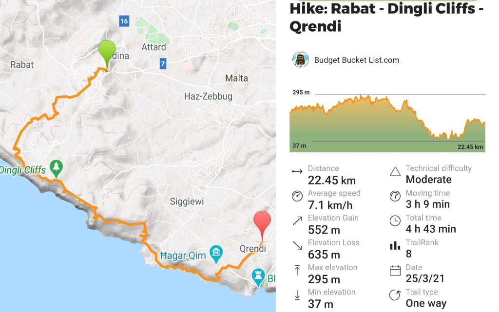
Malta: Rabat – Dingli Cliffs – Qrendi (22.5 km) *****
An extension of previous mentioned section. The landscape remains spectacular until Birzebuggia, where a more industrial character starts dominating. However this track connects two pleasant towns that didn’t lose touch with the true Maltese spirit: Rabat and Qrendi.
Terrain: Trails and some sidewalks.
Level of difficulty: Easy.
Towns (water / food): Rabat, Qrendi. In summer, there are some restaurants and food trucks available along the Dingli Cliffs.
Buses to beginning / end point: Rabat: Bus 51, 52, 53, 181, 182. Qrendi: Bus 72, 74, 218.
Remarks: For a proper challenge, combine with previously mentioned hike. Don’t skip on the small towns capturing local Maltese spirit.
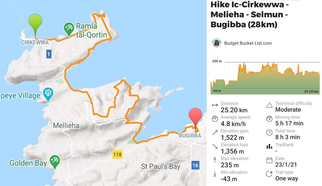
Malta: North-East Coast Stretch (28 km) *****
I completed this hike in my first week of in Malta, during a 7-day-hiking-frenzy trying to figure out where I wanted to settle down (I temporarily stayed in a work apartment in the St. Julians / Sliema area and passionately hated the place – at least I knew where I did NOT want to live). From the Ic-Cirkewwa ferry terminal I bent off into the direction of L-Armier, which was love at first sight. It might come off as some kind of trailer park with random rundown fishing sheds, but I felt the spirit of the place: local, down-to-earth, and unpretentious. Real. I immediately considered it as an option to actually live, only to figure out later that running water and internet is a rare commodity in this area (not ideal for a remote IGaming job). From this stretch on it continues to be an ongoing sequence of splendour, leading past the Crystal Lagoon Sinkhole (be aware: hard to navigate surface for about 5km), the green stretches of green coast at the L-Ahrax side of the peninsula, Għadira Bay (longest beach of Malta), the modern beach town of Mellieha, Selmun, the rocky hiking area around Imgiebah Bay, the coastal stretches around Mistra and Xemxija, St. Paul’s Bay and the multi-culti town of Bugibba.
In short: Fishing villages, the best camping spots, and a selection of sand beaches. What else can you wish for?
Terrain: Trails and sidewalks.
Level of difficulty: Moderate.
Towns (water / food): Ferry Terminal, L-Armier, Mellieha, Selmun, Mistra, Xemxija, St. Paul’s Bay, Bugibba.
Buses to beginning / end point: Ferry Terminal: Bus 133. Bugibba: Bus 31, 38, 39, TD13.
Remarks: One stretch has no internet coverage or GPS-signal and as such the trail wasn't recorded correctly there. We're looking at a total of 28km.
Malta: Marsaxlokk – Marsaskala (12.3 km) ****
A really easy one for you, if you have an hour or two left. Kicking off at the authentic fisherman town of Marsaxlokk, one of my top-spots in Malta, following the coast to the trendier and more vibrant seaside town of Marsaskala. Once again, this hike is best attempted in spring, when the overwhelming greenery, alternated with the oddly-shaped white, smooth rocks bending towards the ultramarine shades of the Mediterranean. If you follow the entire coastal stretch, you’ll not only see the Instagram-famous St. Peter’s Pool, but also the neighbouring bays that are both quieter and less polluted, yet equal in scenery.
Terrain: Trails.
Level of difficulty: Easy.
Towns (water / food): Marsaxlokk, Marsaskala.
Buses to beginning / end point: Marsaxlokk: Bus 80, 81, 82, 85. Marsaskala: Bus 92, 93.
Remarks: This stretch was also covered in “Day 7: Marsaxlokk – Cospicua (Bormla) (30.4 km)”, so I recommend checking that trail on Wikiloc.
Malta: Marsaskala – The Three Cities (12.6 km) ***
To add more of a challenge to your day and walk a total 25 km, I recommend gluing this stretch to the previously mentioned hike. Take in the pleasant yet small-scale urban scenery of Marsaskala, and continue along the extension of this coastline. Less green, rougher, and rockier, yet chockfull of history. You’ll pass several forts along the way, among others Fort Rinella where blockbusters such as Troy and the Gladiator were filmed.
Terrain: Combination of trails and sidewalks.
Level of difficulty: Easy.
Towns (water / food): Marsaxlokk, Marsaskala, Xghajra, Kalkara, Birgu, Bormla / Cospicua.
Buses to beginning / end point: Marsaxlokk: Bus 80, 81, 82,85. Bormla: Bus 1, 2, 3, 4, 124, 213
Remarks: This stretch was also covered in “Day 7: Marsaxlokk – Cospicua (Bormla) (30.4 km)”, so I recommend checking that trail on Wikiloc.
|
|
|
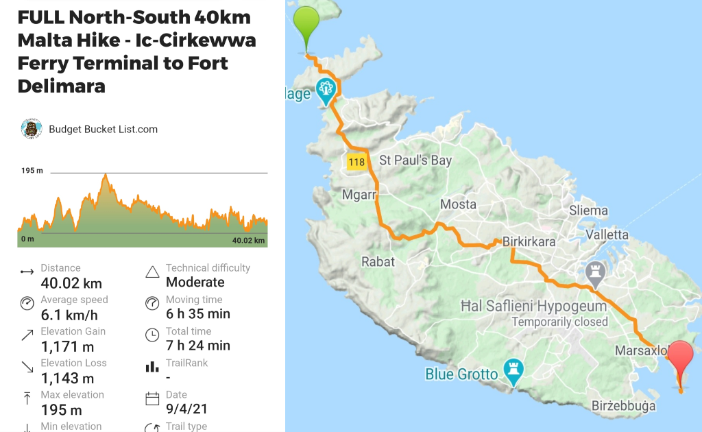
Malta: Full North-South Trek (40 km) ***
I never planned on doing this. I guess when someone told me this is only possible for the fittest of people with an extremely early start, the first seed was planted: besides hiking, proofing people wrong about what I can and cannot do is my fervent passion. Unless I have absolutely no choice, the productivity-switch in my brain isn’t turned on before 11AM and after at least 3 coffees. Night owl, morning zombie: All sleep matters! Time to make a stand for the late risers! No earlier than 1:30PM I kicked off at the northern Ic-Cirkewwa Ferry Terminal, without any concrete plans about where to hike to that day.
25km down the road, realizing I have been somewhat vertically cutting through the island, a little voice in my head said, "this is complete madness, but if you can walk from the absolute North to the absolute South of Malta in 1 afternoon you may crown yourself the f*cking Queen of Malta." I knew the island is about 30km long if you draw a vertical straight line… But the roads and trails are far from vertical, swirling up and down left and right over the island, so I knew I was looking at around 40km, because of course I don't want to walk along a highway, but a slightly scenic route. Like everything in my life, every ridiculous thought or brainfart has to immediately be put into action, as words are just too easy. So I did it. Just after sunset I reached the most southern point of the island of Malta: Fort Delimara. I pumped out 40 km exactly. In 6.5 hours. Crown, please.
Was it the most scenic hike ever? No. Malta is famous for its rugged coastline, the countryside is a simple but pleasant bonus (and the traffic-clogged highways a necessary evil). But it’s pretty cool to just traverse a country in one afternoon.
Terrain: Trails.
Level of difficulty: Easy.
Towns (water / food): Marsaxlokk, Marsaskala.
Buses to beginning / end point: Marsaxlokk: Bus 80, 81, 82,85. Marsaskala: Bus 92, 93.
Remarks: -
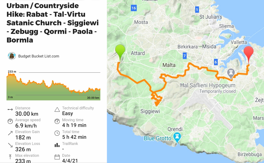
Malta: Rabat / Tal-Virtu Satanic Church towards Three Cities (30 km) ***
You only have to name-drop “Satanic church” once for me to be already on my way. Especially on the holy Easter celebration, double bonus! Abandoned after World War II, the chapel and the land were sold to a German entrepreneur who left the place empty. Over time, Satanists in the area decided to use the space for meetings and rituals and took over and desecrated the chapel, claiming it as their own. Symbols were carved into the floor and then filled with molten tar, and overturned crucifixes were carved into the walls and painted in black over the altar. In short: Cool shit.
Mind you: the church is currently private property and inaccessible to the public… or at least, to the public that has an issue with climbing walls and trespassing. As I don’t belong to the last category, I put up my hood and morphed my way in. Unfortunately, the chapel itself is tightly barricaded, so no inverted crosses to admire. The exterior is captivating, but it felt like a slight let-down after all my efforts. Nevertheless, a nice trigger on an overall pleasant countryside and urban hike through the interior of the island – showing a bit of the lesser-known parts of the interior, sometimes laidback and rather scenic, sometimes unattractive, and noisy.
Terrain: Combination of trails and sidewalks.
Level of difficulty: Easy.
Towns (water / food): Rabat, Siggiewi, Zebug, Qormi, Paola, Bormla.
Buses to beginning / end point: Rabat: Bus 51, 52, 53, 181, 182. Bormla: Bus 1, 2, 3, 4, 124, 213
Remarks: Trespassing involved
Non-Recommended Day Hikes
Malta: Three Cities towards Il-Maqluba Sinkhole & Blue Grotto (22.5 km) **
The Il-Maqubla Sinkhole is nice, and so is the tourist magnet Blue Grotto. However, this hike is not. There are other ways to see it. I simply woke up, drank a cup of coffee, and started walking from my house in the Three Cities and looped the same way back. Turns out: that’s not the way to do it unless you’re really hot for highways. For me the biggest nuisance of Malta is its blaring motorways stuffed with downright madmen-drivers, as well as the ongoing construction works… and this trail is about 70% leading past that shit. And as the ultimate anti-climax: I ended up thinking I saw the Blue Grotto (finding it remarkably underwhelming), only to conclude during later visits I hadn’t seen it all: I turned back a bay too early.
Malta: Marsaxlokk towards Safi (24.5 km) **
Marsaxlokk is always a good start, but it really goes downhill from there. I really don’t understand why Birzebuggia’s beach is called “Pretty Bay”, as I can’t figure out how it could possibly be more disappointing… overlooking the cranes and container ships of the industrial harbour right next to it. The whole stretch is basically a highly polluted stretch of industrial zone, with the promising outlook to reach the Ghar Hassan Cave at some point… Yet another letdown, closed off and currently serving as an improvised homeless shelter reeking of vomit and piss. I gave up and went home…via Safi, a pleasant little village worth a quick pitstop, preferably unrelated to this major flop of a walk.
Malta: St. Julian’s towards the Three Cities (19.5 km) *
If you’re curious about the most revolting parts of Malta, this hike got you covered. This is a personal opinion, as apparently 95% of the expat population is full-on charmed by the “delights” of modern St. Julian’s and Sliema… but I spent 7 months wondering why. All I see is an unattractive collection of hastily pumped-out-of-the-ground cheaply built apartment complexes, glued together by a long and boring sidewalk marketed as “the promenade”, denying absolute everything true or authentic Malta represents. Yet, people pay outrageous rental prices to be amongst the noise and chaos, so I must be overseeing something. That said, this hike basically follows the above-mentioned “promenade” and then leads straight into the industrial zone of Albert Town (where the refugees are chucked into), connected by 4-lane highways. Fun! Luckily it ends at what I consider the most captivating and alluring part of entire Malta: The Three Cities, my temporary home.
Malta: St. Julian’s towards the Bugibba / Salina and back into Gharghur (24.5 km) *
All of the above-described horror, but instead ending in the very pleasant surprise called "Gharghur": a little-known “typical Maltese” town on top of a hill, overlooking the entire island. My Plan B if the Three Cities didn’t work out. This trail leads up to the nightlife area of Paceville, the trailer camp of Bahar and the rocky coastline towards Bugibba. In theory, that coastline could be pleasant, if the raging highway wasn’t built right along it, disturbing the peace and nature-experience that I generally look for in a hike. On the way to Gharghur I got lost in several construction sites, which perhaps represents the new Maltese culture… who knows? The only upside presented itself in the form of the magnificent street art on some deserted apartment buildings just past Bahar (trespassing required). Yeah… you can skip this one.
Tips:
- Hiking in Malta is most beautiful in spring, when climates are moderate and the entire island is in bloom. Winter and autumn are suitable, but hiking in summer is not recommended. Not only for the landscapes, that have turned to dust under the unforgiving sun, also for safety, as with climates up to 48-49 degrees Celsius sunstrokes and severe dehydration are a serious risk.
- However, keep in mind that everything but summer is considered “low season” or “shoulder season” in Malta, and there are no points where food or water can be bought outside of the towns. In summer, food and beverage trucks can be found all along the coastline. Always bring more water than you think you need.
- Civilization is never far away in tiny Malta, but always inform someone about your hiking route and intended return time. Better safe than sorry.
- For GPS navigation and tracing down trails, Maps.me is quite reliable and works offline. You can download all Wikiloc trails for offline use. A simcard costs 10 euros, and for 5.99 you have 4GB of data for 4 weeks (Epic), which might be worth purchasing.
- Come prepared. My standard day hiking kit consists of a first aid kit, foot tape, head lamp and spare batteries, matches and a lighter, duct tape, a rope, reflectors, sunscreen, hat, a life-straw or water purifying tablets, an emergency blanket, a thick removal pen and a pocketknife.
In order to support the travelers’ community, I spend many hours per week to adequately document all information and advices for prospective visitors, accompanied by a (hopefully) entertaining insight into my personal observations and experiences. This service is and will remain free. However, if you voluntarily want to make a contribution and support my travels and thus the creation of new stories and information supply, here is the button you’re looking for:
Related:
- More Malta - check the blogs!
- Explore Cyprus: Check out the Cyprus Nature, Cyprus Top-5 Cities and the North Cyprus Blogs!
- Budget Bucket List's Best Hiking Destinations - an overview
- Check out all Camino Frances stories right here!
- Hiking Poland's longest mountain trail (550km) with a tent: Glowny Szlak Beskidzki - check the reports here!
- Europe's best skiing & hiking: Get your ass over to jaw-dropping Switzerland!
- Visit Portugal: Hike the Rota Vicentina (Fisherman's Trail)
- Complete hiking guide to Cameron Highlands [Malaysia]
- Borneo's main hiking destination: Kuching - in's & out's
- Getting lost in the freezing wilderness of Chilean Patagonia: Rough times on my 5-day hike in Torres del Paine
- Peru's hiking capital: Huaraz! The best overnight treks & day hikes!
- Hiking Argentinean Patagonia: The best walks in Bariloche, El Chaltén, Esquel and Ushuaia
- Going off-grid in Bolivia: Multi-day hiking trips in the mountains of Sucre & Sorata
- Hike the national parks of Brazil!
- Boiling hot hiking: Natural endeavours in Paraguay
- 2 months in Boquete: Panama's Hiking Capital!
- Discover New Zealand: The world's best hikes crammed in 1 country!
- The Austrian Alps: Top Ski Resorts
- The best hiking destinations of Armenia: Mount Aragats, Dilijan and the southern Legend's (Transcaucasian) Trail
- Climbing Mount Vitosha: Bulgaria's most famous mountain
- Hitchhiking Transylvania: The green heart of Romania
- Why are Koreans the world's most enthusiast hikers? Read more about Korea's national parks!
- Check out Budget Bucket List's FAVORITE HIKING DESTINATIONS worldwide!
- Visit Balkan's finest: Montenegro's National Parks Blog, Kotor Bay & Lovcen NP and Cetinje, Durmitor NP, Podgorica, Prokletije NP and Montenegro's Coastal Towns Blog
- Archeological treasures, UNESCO sights and Greece's roughest nature: Explore the Peloponnese!